
 SMIC News Issue 69, dated August 2022, including the 178th GM and 34th AGM, upcoming events, industry reports, surveying education reports, surveying ans SIS traineeeships, and the SMIC Training and Scholarship Program.
Industry News
Here is the latest industry news. Don't forget to also regularly check the Members Notices page and Events page!
 Thank you for those who attended the AIMS National Conference 2022. After a long break due to COVID we were pleased to be all together again up on the Gold Coast to celebrate the return of the Conference.
 SMIC News Issue 68 from May 2022, including the 177th GM, upcoming events, industry reports, surveying education reports, surveying ans SIS traineeeships, and the SMIC Training and Scholarship Program.
 SMIC News from March 2022, including the 176th GM, upcoming events, industry reports, surveying education reports, surveying ans SIS traineeeships, and the SMIC Training and Scholarship Program.
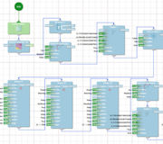 Maptek workflows can automate and streamline processes for underground and open pit mines, increasing efficiency and making it easy for new users to step into a task.
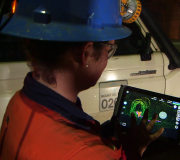
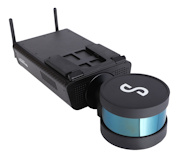
 Emesent has announced the launch of Hovermap ST, the latest version of their world-leading Hovermap autonomy and mapping payload. The tough, lightweight, IP65 rated Hovermap ST is being launched with Emesent’s new Automated Ground Control feature.
 Glencore's Mount Isa Mines deploys autonomous technology to improve survey efficiency and safety.
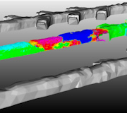
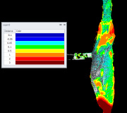 Hear Linda Snyman, Senior Operations Geotechnical Engineer, CMOC Northparkes Mines, describe how they conduct annual scans of a 560 m intake vent and conduct change detection analysis to assess the rate of self-mining in a failed lower section.
 SMIC News Issue 66 includes information on the 175th GM, upcoming events, industry reports, surveying education reports, surveying and SIS traineeships and the SMIC Training and Scholarship Program.
 Making geological modelling simple is the premise of Vulcan GeologyCore, released by technology developer Maptek in September 2021.
 SMIC News Issue 65 - August 2021 including info on the 174th General Meeting, Upcoming Events, Industry Reports, Surveying Education Reports, Surveying & SIS Traineeships, and the SMIC Training & Scholarship Program.
 Oz Minerals uses Hovermap in many ways to capture data in areas that were not previously accessible to improve the efficiency and decision-making of their engineers.
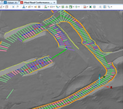 Mining companies want to maintain a safe working environment. Well designed and maintained haul roads are the key to minimising costs and improving productivity.
 Maptek sensing systems are extremely safe and easy to use, collecting mining or large civil project data and feeding results and reports to downstream consumers.
 In December 2019, Rio Tinto engaged MineLiDAR to trial Hovermap for convergence monitoring at its Argyle Diamond Mine, in Western Australia.
 A new e-book has been published by Hexagon outlining the benefits of combined radar and geodetic monitoring.
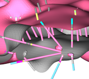
 Emesent and Datamine have partnered to enable geotechnical structure mapping in stopes and other inaccessible areas.
 SMIC News Issue 64 - May 2021 including info on the 173rd General Meeting, Upcoming Events, Industry Reports, Surveying Education Reports, Surveying & SIS Traineeships, and the SMIC Training & Scholarship Program.
 Preservation of Survey Infrastructure (POSI) applications will soon be directed to contact Survey Operations through the new DCS Spatial Services user-friendly Customer Hub.
 In the mid 1970s, geologist Bob Johnson opened a small bureau service above a row of shops in suburban Sydney, NSW, to computerise coal seam drafting. That venture was the precursor to Maptek, which today develops, sells and supports innovative mining solutions to more than 20,000 users worldwide.
- SMIC News - February 2021
- Case Study: Significant State Development
- Webinar - Mungari Gold Mine Improves Stope Design
- Kiruna Mine Case Study - Fall of Ground Inspections
- SMIC News - December 2020
- SMIC News - August 2020
- SMIC News - April 2020
- SMIC News - February 2020
- Monitoring of Tailings Dams
- A Reflection on Technology Evolution
- Proximity Detection and Collision Awareness Technology
- SMIC News - December 2019
- AIMS Extends "A Life Without Limits" Program Support
- AIMS Presents at Otago University School of Surveying
- SMIC News - August 2019
- AIMS/RMIT Scholarship Awarded
- SMIC News - April 2019
- Latest Deswik module creates survey solids from scan data in no time
- SMIC News - March 2019
- BOSSI Statistical Review